Yo Momma in CEBU

Hyper Cebu's #HyperHalloween

Monday, October 20


Hi Mommsies!

Prepare yourselves, because FEAR IS COMING. HYPER CEBU in collaboration with Parkmall and the City Government of Mandaue presents #HYPERHALLOWEEN coming this October 24-26, 2014. 

Strengthened and organized by the commitment of JCI Cebu Inc and Hyper Volunteers comes a spooktacular event this October. Following its latest tradition, there will be a weekend food market, a lifestyle bazaar, a bloggers meet, an indie music fest and a rave party in one destination. Another gathering of foodies, fashionistas, travelers, techies and musicians to empower and showcase youth entrepreneurship talent and culture.

On this event, Hyper Cebu will be introducing a new Cebuano passion: Fitness, to foster sportsmanship and promote an active and better lifestyle for all Sugbuanons. In line with this, we will be launching the #HyperHalloween Zombie Run. A fun run, first in Cebu, with military-like obstacles and a zombie survival arena with a 1.6K, 3K and 5K distance. Registration starts at 300 Pesos, 350 Pesos and 400 Pesos respectively at Runnr Ayala. Another first brought to you by Hyper Cebu.

#HYPERHALLOWEEN will also be making history by Gathering 25 of Cebu’s best DJs representing the 9 well-known clubs across the city of Cebu; The Distillery Cebu, Cable Car Cebu, Den, LIV Superclub, The Barcode, Alchology, Basic, Dozo Izakaya and J.Ave Superclub.

Being a charity and volunteer-ran event, this will be for the benefit of:

1) CEVSAR / Central Visayas Search & Rescue Group Incorporated

2) BIDLISIW Foundation a social welfare and development agency whose focused on helping the urban poor families, particularly the informal settlers in the cities of Cebu, Mandaue and Talisay

3) COLORS / Coalition for the Liberation of the Reassigned Sex. A foundation who aims to establish a united, strong, and empowered transgender community that nurtures to their well-being and welfare and rebuild a discrimination-free and equal society.

4) TEDxUniversityofSanCarlos - TEDx is an independently-organized TED event by Carolinian students where people in Cebu come together to share ideas worth spreading through live speakers, TED videos and interesting conversations.

GENERAL AD ACCESS CARDS ARE AVAILABLE AT PHP 250 AND VIP AT PHP1000.
For more information, please send an email to hypercebu@gmail.com or find us at www.facebook.com/hypercebu. For Ticket & Booth Inquiries 09322326992. Look for Bryan.


FREE Fashion Photography Workshop at Ayala

Thursday, June 19


see you there!!!! =)

Sinulog 2014: Security Tips

Tuesday, January 14

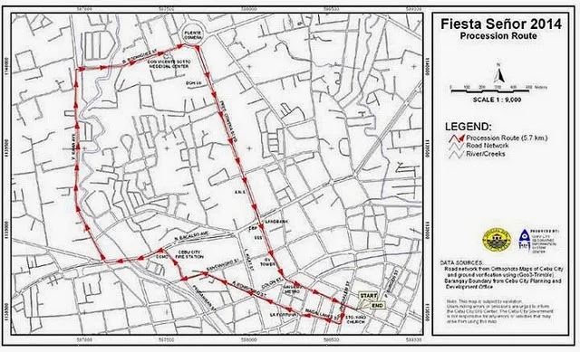
Here are some few personal security tips for the coming Sinulog that I'd like to share with you...  Pit Senyor!!!


PERSONAL SECURITY
This guide is full of tips that can help you avoid becoming a victim of a crime when you are out and about enjoying the solemn procession or the street party. By taking a few simple precautions, you can reduce the risk to yourself, and also discourage those who commit crime. Bear in mind that a lot of other people are coming to visit and watch the celebration, this may include bad elements.


Sinulog 2014 Schedule 
Sinulog 2014 Traffic Schedule


Be prepared
  • Always be alert and aware of the people around you.
  • Educate yourself concerning prevention tactics.
  • Be aware of locations and situations which would make you vulnerable to crime, such as alleys and dark parking lots.
Street precautions
  • Be alert to your surroundings and the people around you, especially if you are alone.
  • Whenever possible, travel with a friend.
  • Stay away from very crowded areas as much as possible.
  • Walk confidently, and at a steady pace.
  • Make eye contact with people when walking.
  • Do not respond to conversation from strangers on the street, continue walking.
  • If you carry a purse, hold it securely between your arm and your body.
  • If you carry a Camera or any electronic devices with you, make sure it is attached to your body with a use of a sling.
Car safety
  • Always lock car doors after entering or leaving your car.
  • Park in well maintained areas.
  • Have your car keys in your hand so you don't have to linger before entering your car.
  • Check the back seat before entering your car.
  • If you think you are being followed, drive to a public place or a police, or fire station.
  • Don't stop to aid motorists stopped on the side of the road. Go to a phone and request help for them.
  • Lexmark Parking area is open for employees.
Additional Tips
  • Avoid bringing too much valuables while enjoying the Street Party.
  • Wear comfortable clothes, shirts, pants, etc. . . .
  • Don't forget to bring your own bottled water, if you need to buy one, buy from a reliable source.
  • Don't invite trouble — keep gold chains out of sight; don't flash your jewelry; and turn your rings around so the stones don't show.
If a crime occurs – report it!
Everyone should consider it his/her responsibility to report crime. Many criminals target favorite areas and have predictable methods of operation. When you report all the facts about a crime, it helps the police assign officers in the places where crimes are occurring or where they are most likely to occur. At least one out of two crimes in the United States goes unreported, either because people don't think the police can do anything about it, or because people don't want to get involved. If you don't report crime, this allows the criminal to continue to operate without interference. 


Enjoy!

Dont forget to follow my blog on Bloglovin': http://www.bloglovin.com/blog/3866120

And Yet Another Typhoon to Hit Cebu

Wednesday, November 6

To all Mommsies in Cebu and Central Visayas, let's pray and prepare! 


WEATHER.COM.PH TROPICAL CYCLONE UPDATES
TYPHOON HAIYAN UPDATE NUMBER 004 
Issued at: 6:00 AM PhT (22:00 GMTWednesday 06 November 2013
Next Update: 12:00 NN PhT (04:00 GMTWednesday 06 November 2013


HAIYAN approaching Super Typhoon (STY) status as it rapidly gained strength due to the emergence of a pinhole-sized eye a few hours ago...now poses a serious threat to Eastern Visayas and Northeastern Mindanao. The initial potential landfall area of this typhoon remains along the Samar-Leyte Area on Friday morning, November 08

This typhoon is similar in track and strength of Super Typhoon MIKE (RUPING) which passed across the Visayas in November of 1991 and devastated much of Metro Cebu. Residents living along the eastern seaboards of the Philippines from Northern Quezon...Bicol Region...down to Northeastern Mindanao should closely monitor the approach of this potentially destructive typhoon. Plans for emergency situations and/or disaster management planning must be implemented beginning today as the storm is only 3 days away from hitting land.


Meanwhile, Tropical Depression 30W (WILMA) has accelerated and is approaching the coast of Southern Vietnam. As of 5:00 am today, its center was estimated about 385 km ESE of Nha Trang, Vietnam (near 11.8N 112.7E). With maximum winds of 55 kph near the center and was moving westward at 31 kph in the general direction of Southern Vietnam. 

Residents and visitors along Northeastern Mindanao, Visayas, Bicol Region and Eastern Luzon should closely monitor the development of Haiyan.
 

Do not use this for life or death decisions. This update is intended for additional information purposes only. Kindly refer to your national weather agency for official warnings, advisories or bulletins.


CURRENT STORM ANALYSIS 


As of 5:00 am today, the pin-hole eye of TY Haiyan was located over the western part of the Caroline Islands...about 335 km southeast of Colonia, Yap (FSM) or 1,690 km southeast of Borongan City, Samar, Philippines...currently moving quickly west-northwest with an accelerated forward speed of 35 km/hr towards Yap-Palau Area. 

Maximum Sustained Winds (1-min. avg) have rapidly increased to 205 km/hr near the center with higher gusts. Typhoon Force Winds (118 km/hr or more) extend outward up to 45 kilometers from the center...and Tropical Storm Force Winds (63-117 km/hr) extend outward up to 165 kilometers from the center. TY Haiyan remains a small-sized tropical cyclone with a diameter of 555 kilometers across.

2-DAY FORECAST OUTLOOK* 

TY Haiyan is expected to move in a generally straight, west-northwest track throughout the forecast period. On the forecast track, the core of TY Haiyan will passing in between the islands of Yap and Palau by Wednesday afternoon and evening...and will enter the Philippine Area of Responsibility (PAR) during the early morning hours of Thursday...and move across the South Philippine Sea. By early Friday morning, Haiyan will be at near landfall, approaching the shores of Southern Samar and Eastern Leyte. 

TY Haiyan will continue to rapidly intensify within the next 24 to 48 hours as the system moves over the warmer sea surface temperatures of the Philippine Sea...and could become an extremely dangerous Category 5 STY on Thursday early morning just before it makes landfall. Advance Intensity Forecast (AIF) shows its 1-minute maximum sustained winds increasing to 260 km/hr between the evening ofWednesday and early Thursday morning. 

The following is the summary of the 2-day forecast outlook and an extended 3-day forecast on this system:

 THURSDAY EARLY MORNING: Enters the P.A.R. at Category 4 strength while passing close to the Republic of Palau...moving over the South Philippine Sea...about 160 km north-northeast of Koror, Palau[2AM NOV 07: 8.7N 134.9E @ 250kph].
 FRIDAY EARLY MORNING: Strengthens to a Category 5 STY as it prepares to make landfall over Southern Samar...about 290 km southeast of Borongan City, Eastern Samar [2AM NOV 08: 10.7N 127.9E @ 260kph].
 SATURDAY EARLY MORNING: Moving across Mindoro Strait after traversing Northern Visayas...weakens to Category 4...about 60 km north-northeast of Coron, Palawan [2AM NOV 09: 12.5N 120.4E @ 215kph]

*Please be reminded that the Forecast Outlook changes every 6 hours, and the Day 2 and 3 Forecast Track has an average error of 100 and 250 km respectively...while the wind speed forecast error, averages 35 kph per day. Therefore, a turn to the left or right of its future track and changes in its wind speed must be anticipated from time to time.

EFFECTS & HAZARDS SUMMARY 

Below is the summary of the storm's parts and its hazards affecting specific areas. You can also view this image link for you to understand the parts. 

 PIN-HOLE EYE - over water. Possible calm and lull conditions (with <20 be="" expected="" eye="" i="" inside="" kph="" nbsp="" the="" will="" winds="">(click here to know more about the EYE).

 EYEWALL - where Typhoon Conditions with Typhoon Force Winds (>118 kph) will be expected within this wall. Affected Areas: None (click here to know more about the Eyewall).
 INNER RAINBANDS - where Tropical Storm Conditions with Tropical Storm Force Winds (63-100 kph) will be expected. Affected Areas: None.
 OUTER RAINBANDS - where Tropical Depression Conditions with light, moderate to strong winds (30-62 kph) will be expected. Affected Areas: Yap State (Federated States of Micronesia) and approaching the Republic of Palau (click here to know more about Rainbands).
 24HR TOTAL RAINFALL ACCUMULATION - from 5 up to 100 mm (slight to heavy rainfall) can be expected along areas affected by the outer & inner rainbands (see above)...with isolated amounts of 101 to 210 mm (heavy) along areas near the center of Haiyan.
Important Note: Please keep in mind that the above forecast outlook, effects and hazards summary changes every 6 to 12 hrs!


CURRENT TECHNICAL INFORMATION 

Time/Date: 5:00 AM PhT Wed Nov 06, 2013
Class/Name: TY Haiyan (31W)
Location of Eye: Near 7.3º N Lat 140.2º E Lon
Distance 1: 335 km SE of Yap State 
Distance 2: 575 km E of P.A.R.
Distance 3: 630 km E of Republic of Palau
Distance 4: 1690 km SE of Borongan City
Distance 5: 1725 km ESE of Tacloban City
MaxWinds (1-min avg): 205 kph near the center
Peak Wind Gusts: 250 kph 
Saffir-Simpson Hurricane Scale: Category 3
Present Movement: WNW @ 35 kph
Towards: Yap-Palau Area
CPA [ETA] to Samar-Leyte: Friday Morning [between 7AM-9AM PhT]
Minimum Central Pressure: 941 millibars (hPa) 
T2K/WP StormTracks (for Public): GIF | Google Map (Flash)

Kanebo Beauty Workshop here in Cebu City

Thursday, February 21

Hi everyone! 

This is a repost from Random beauty by Hollie

I'd like to share with you this invite from Kanebo Philippines.  They are inviting us beauty enthusiasts to their Private Sale and Beauty Workshop here in Cebu City.


You will have a chance to experience the Kanebo Beauty Workshop. It will be held at Marriot Hotel here in Cebu City on February 28, 2013 at 1:00 PM to 5:00 PM.

Learn how to look fresh in vivid colours together with their local guest makeup artist, Mr. John Rubi. You also get first dibs on the Lunasol Spring Summer Makeup Collection 2013.  

Workshop Fee is only Php 500.00 and you can use that to redeem Kanebo products. The event will include a Makeup Workshop, Skincare Application and Snacks.

Please make RSVP to:
Yannie  @ +63 922-8672309
Judith   @ +63 905-7735789
Cristine @ +63 927-9128137

Till next post.

Cheers!


© Nanay Kikay. Design by Fearne.